THE REQUIREMENTS OF MARINE CADASTRE IN THE REQUIREMENTS OF MARINE CADASTRE IN TURKEY ... Kuala...
8
F THE REQUIREMENTS OF MARINE CADASTRE IN TURKEY Yasar Selcuk ERBAS, Recep NISANCI, A. ERDEM OZCELIK and TAHSIN YOMRALIOGLU (Turkey) [email protected] Karadeniz Technical University Geographic Information Systems Laboratuary/GisLab XV FIG CONGRE 16-21 June Kuala Lu XXV International Federation of Surveyors Congress, Kuala Lumpur, Malaysia, 16 – 21 June 2014 F ASTRE AND MARINE CADASTRE XV FIG CONGRE 16-21 June Kuala Lu adastre (also spelled cadaster), using a cadastral survey cadastral map, is a comprehensive register of the real tate or real property's metes-and-bounds of a country. • A cadastre commonly includes details the ownership, the tenure, the precise loca (some include GPS coordinates), the dimensi (and area), the cultivations if rural, and the valu individual parcels of land. XXV International Federation of Surveyors Congress, Kuala Lumpur, Malaysia, 16 – 21 June 2014
Transcript of THE REQUIREMENTS OF MARINE CADASTRE IN THE REQUIREMENTS OF MARINE CADASTRE IN TURKEY ... Kuala...
F
THE REQUIREMENTS OF MARINE CADASTRE IN TURKEY
Yasar Selcuk ERBAS, Recep NISANCI, A. ERDEM OZCELIK and TAHSIN YOMRALIOGLU (Turkey)
Karadeniz Technical University Geographic Information Systems Laboratuary/GisLab
XV FIG CONGRESS16-21 June Kuala Lumpur
XXV International Federation of Surveyors Congress, Kuala Lumpur, Malaysia, 16 – 21 June 2014
F
CADASTRE AND MARINE CADASTRE
XV FIG CONGRESS16-21 June Kuala Lumpur
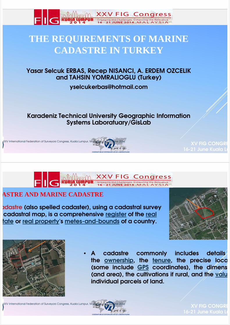
Cadastre (also spelled cadaster), using a cadastral survey cadastral map, is a comprehensive register of the real
estate or real property's metes-and-bounds of a country.
• A cadastre commonly includes detailsthe ownership, the tenure, the precise location(some include GPS coordinates), the dimensions(and area), the cultivations if rural, and the valueindividual parcels of land.
XXV International Federation of Surveyors Congress, Kuala Lumpur, Malaysia, 16 – 21 June 2014

F
CADASTRE AND MARINE CADASTRE
XV FIG CONGRESS16-21 June Kuala Lumpur
• In these days, of the cadastre as well as marine cadastre
also mentioned. There are two definitions of marine cadastre
is a marine information system, encompassing both the nature and spatial extent of
interests and property rights, with respect to ownership, various rights and responsibilities
marine jurisdiction.
1. Marine cadastre is a system to enable the boundaries of maritime
rights and interests to be recorded, spatially managed
physically defined in relationship to the boundaries of
neighbouring or underlying rights and interests,
XXV International Federation of Surveyors Congress, Kuala Lumpur, Malaysia, 16 – 21 June 2014
XXV International Federation of Surveyors Congress, Kuala Lumpur, Malaysia, 16 – 21 June 2014
F
AIM OF STUDY ?
XV FIG CONGRESS16-21 June Kuala Lumpur
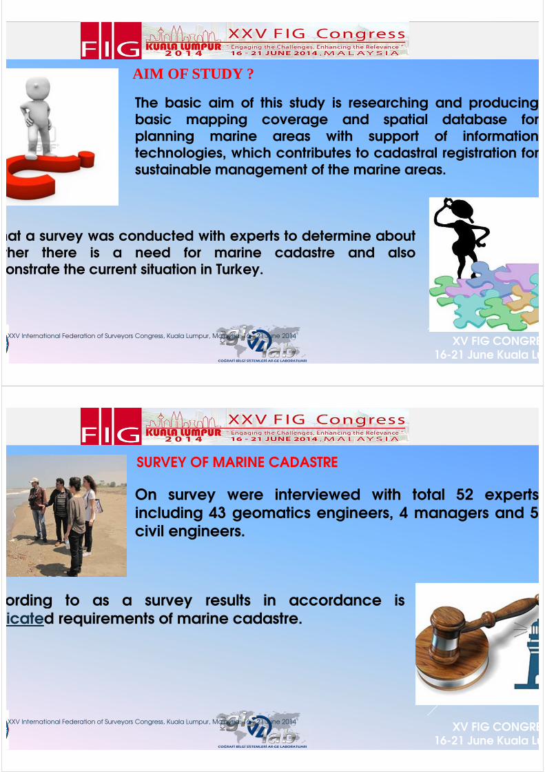
The basic aim of this study is researching and producingbasic mapping coverage and spatial database forplanning marine areas with support of informationtechnologies, which contributes to cadastral registration forsustainable management of the marine areas.
that a survey was conducted with experts to determine aboutwhether there is a need for marine cadastre and alsodemonstrate the current situation in Turkey.
XXV International Federation of Surveyors Congress, Kuala Lumpur, Malaysia, 16 – 21 June 2014
F
SURVEY OF MARINE CADASTRE
XV FIG CONGRESS16-21 June Kuala Lumpur
On survey were interviewed with total 52 expertsincluding 43 geomatics engineers, 4 managers and 5civil engineers.
According to as a survey results in accordance isexplicated requirements of marine cadastre.
XXV International Federation of Surveyors Congress, Kuala Lumpur, Malaysia, 16 – 21 June 2014
F
SURVEY RESULTS
XV FIG CONGRESS16-21 June Kuala Lumpur
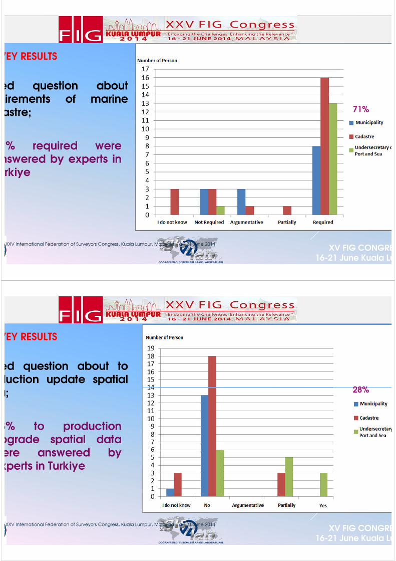
Asked question aboutrequirements of marinecadastre;
71% required wereanswered by experts inTurkiye
71%
XXV International Federation of Surveyors Congress, Kuala Lumpur, Malaysia, 16 – 21 June 2014
F
SURVEY RESULTS
XV FIG CONGRESS16-21 June Kuala Lumpur
Asked question about toproduction update spatialdata;
28% to productionupgrade spatial datawere answered byexperts in Turkiye
28%
XXV International Federation of Surveyors Congress, Kuala Lumpur, Malaysia, 16 – 21 June 2014
F
SURVEY RESULTS
XV FIG CONGRESS16-21 June Kuala Lumpur
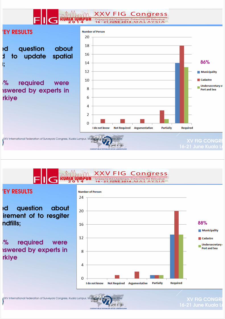
Asked question aboutneed to update spatialdata;
86% required wereanswered by experts inTurkiye
86%
XXV International Federation of Surveyors Congress, Kuala Lumpur, Malaysia, 16 – 21 June 2014
F
SURVEY RESULTS
XV FIG CONGRESS16-21 June Kuala Lumpur
Asked question aboutrequirement of to resgiter
landfills;
88% required wereanswered by experts inTurkiye
88%
XXV International Federation of Surveyors Congress, Kuala Lumpur, Malaysia, 16 – 21 June 2014
F
OTHER SURVEY RESULTS
XV FIG CONGRESS16-21 June Kuala Lumpur
Asked question about adequacy of studies on marine cadastre, 52% not enough were answered by experts in Turkiye.
Asked question about requirement of to register all usage rights and restrictions belonging to marine area, 48% required were answered by experts in Turkiye.
Asked question about protected areas should be added to registration applications of use of marine areas, 86% required were answered by experts in Turkiye.
Asked question about need to update landfills areas on shore, 86% need to were answered by experts in Turkiye.
Asked question about requirement of measurement of all usage rights and restriction on shore areas, 84% required were answered by experts in Turkiye. In addition, shoreline must be measured and registered.
XXV International Federation of Surveyors Congress, Kuala Lumpur, Malaysia, 16 – 21 June 2014
F
CONCLUSION
XV FIG CONGRESS16-21 June Kuala Lumpur
In the world and Turkiye, when applications are studied about marine areas, marine cadastre concept is very common in developed countries. This new concept is began to new emerging and spread forTurkiye.
According to this research, studies or arrangements must be made with different professional groups. For a sustainable management of marine areas, management and implementation of activities on the marine area must be taken under control.
"Geographic Information Systems" (GIS) should be used for under controlling such a this complex structure, storage and processing. GIS will provide a great convenience about marine cadastre model.
Day by day we are losing marine areas so we must protect this areas, prevent the illegal usage, take under control of shore structures and design a sustainable marine cadastre.
XXV International Federation of Surveyors Congress, Kuala Lumpur, Malaysia, 16 – 21 June 2014
F
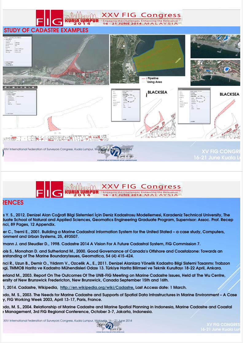
SOME STUDY OF CADASTRE EXAMPLES
XV FIG CONGRESS16-21 June Kuala Lumpur
BLBLACKSEA
BLACKSEA
Pipeline
Using Area
XXV International Federation of Surveyors Congress, Kuala Lumpur, Malaysia, 16 – 21 June 2014
F
REFERENCES
XV FIG CONGRESS16-21 June Kuala Lumpur
Erbas Y. S., 2012. Denizel Alan Coğrafi Bilgi Sistemleri İçin Deniz Kadastrosu Modellemesi, Karadeniz Technical University, The Graduate School of Natural and Applied Sciences, Geomatics Engineering Graduate Program, Supervisor: Assoc. Prof. Recep Nisanci, 89 Pages, 12 Appendix.
Fowler C., Treml E., 2001. Building a Marine Cadastral Information System for the United Stated – a case study, Computers, Environment and Urban Systems, 25, 493507.
Kaufmann J. and Steudler D., 1998. Cadastre 2014 A Vision For A Future Cadastral System, FIG Commission 7.
Nichols S., Monahan D. and Sutherland M., 2000. Good Governance of Canada's Offshore and Coastalzone: Towards an Understanding of The Marine BoundaryIssues, Geomatica, 54 (4) 415-424.
Nisanci R., Uzun B., Demir O., Yıldırım V., Ozcelik A., E., 2011. Denizel Alanlara Yönelik Kadastro Bilgi Sistemi Tasarımı: Trabzon Ornegi, TMMOB Harita ve Kadastro Mühendisleri Odası 13. Türkiye Harita Bilimsel ve Teknik Kurultayı 18-22 April, Ankara.
Sutherland M., 2003. Report On The Outcomes Of The UNB-FIG Meeting on Marine Cadastre Issues, Held at The Wu Centre, University of New Brunswick Fredericton, New Brunswick, Canada September 15th and 16th.
1, 2014. Cadastre, Wikipedia, http://en.wikipedia.org/wiki/Cadastre, Last Access date: 1 March.
Widodo, M. S., 2003. The Needs for Marine Cadastre and Supports of Spatial Data Infrastructures in Marine Environment – A Case Study, FIG Working Week 2003, April 13-17, Paris, France.
Widodo, M. S., 2004. Relationship of Marine Cadastre and Marine Spatial Planning in Indonesia, Marine Cadastre and Coastal Zone Management, 3rd FIG Regional Conference, October 3-7, Jakarta, Indonesia.
XXV International Federation of Surveyors Congress, Kuala Lumpur, Malaysia, 16 – 21 June 2014

F
XV FIG CONGRESS16-21 June Kuala Lumpur
THANKS FOR LISTENING…
Research Assistant Yasar Selcuk ERBASKaradeniz Technical University
Geomatics EngineeringGeographic Information Systems Laboratuary/GisLab
XXV International Federation of Surveyors Congress, Kuala Lumpur, Malaysia, 16 – 21 June 2014
F
XV FIG CONGRESS16-21 June Kuala Lumpur
HOPE TO SEE YOU IN
TURKEYFIG 2018
XXV International Federation of Surveyors Congress, Kuala Lumpur, Malaysia, 16 – 21 June 2014