SURUHANJAYA PELABUHAN PULAU PINANG KENYATAAN … · Dokumen sebut harga hendaklah dimasukkan ke...
43
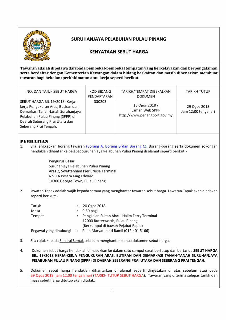
1 SURUHANJAYA PELABUHAN PULAU PINANG KENYATAAN SEBUT HARGA Tawaran adalah dipelawa daripada pembekal‐pembekal tempatan yang berkelayakan dan berpengalaman serta berdaftar dengan Kementerian Kewangan dalam bidang berkaitan dan masih dibenarkan membuat tawaran bagi bekalan/perkhidmatan atau kerja seperti berikut. NO. DAN TAJUK SEBUT HARGA KOD BIDANG PENDAFTARAN TARIKH/TEMPAT DIBEKALKAN DOKUMEN TARIKH TUTUP SEBUT HARGA BIL.19/2018‐ Kerja‐ kerja Pengukuran Aras, Butiran dan Demarkasi Tanah‐tanah Suruhanjaya Pelabuhan Pulau Pinang (SPPP) di Daerah Seberang Prai Utara dan Seberang Prai Tengah. 330203 15 Ogos 2018 / Laman Web SPPP http://www.penangport.gov.my 29 Ogos 2018 Jam 12:00 tengahari PERHATIAN 1. Sila lengkapkan borang tawaran (Borang A, Borang B dan Borang C). Borang‐borang serta dokumen sokongan hendaklah dihantar ke pejabat Suruhanjaya Pelabuhan Pulau Pinang di alamat seperti berikut:‐ Pengurus Besar Suruhanjaya Pelabuhan Pulau Pinang Aras 2, Swettenham Pier Cruise Terminal No. 1A Pesara King Edward 10300 George Town, Pulau Pinang 2. Lawatan Tapak adalah wajib kepada semua yang menghantar tawaran sebut harga. Lawatan Tapak akan diadakan seperti berikut: ‐ Tarikh : 20 Ogos 2018 Masa : 9.30 pagi Tempat : Pangkalan Sultan Abdul Halim Ferry Terminal 12000 Butterworth, Pulau Pinang (Berkumpul di bawah Pejabat Rapid) Pegawai yang dihubungi : Puan Maryati binti Ramli (012‐401 5166) 3. Sila rujuk kepada Senarai Semak sebelum menghantar semua dokumen sebut harga. 4. Dokumen sebut harga hendaklah dimasukkan ke dalam satu sampul surat bertutup dan bertanda SEBUT HARGA BIL. 19/2018 KERJA‐KERJA PENGUKURAN ARAS, BUTIRAN DAN DEMARKASI TANAH‐TANAH SURUHANJAYA PELABUHAN PULAU PINANG (SPPP) DI DAERAH SEBERANG PRAI UTARA DAN SEBERANG PRAI TENGAH. 5. Dokumen sebut harga hendaklah dihantarkan di alamat seperti dinyatakan di atas sebelum atau pada 29 Ogos 2018 jam 12:00 tengah hari (TARIKH TUTUP SEBUT HARGA). Tawaran yang diterima selepas tarikh dan masa sebut harga ditutup akan ditolak.
Transcript of SURUHANJAYA PELABUHAN PULAU PINANG KENYATAAN … · Dokumen sebut harga hendaklah dimasukkan ke...
1
SURUHANJAYA PELABUHAN PULAU PINANG
KENYATAAN SEBUT HARGA
Tawaranadalahdipelawadaripadapembekal‐pembekaltempatanyangberkelayakandanberpengalamansertaberdaftardenganKementerianKewangandalambidangberkaitandanmasihdibenarkanmembuattawaranbagibekalan/perkhidmatanataukerjasepertiberikut.
NO. DAN TAJUK SEBUT HARGA KOD BIDANG PENDAFTARAN
TARIKH/TEMPAT DIBEKALKAN DOKUMEN
TARIKH TUTUP
SEBUT HARGA BIL.19/2018‐ Kerja‐kerja Pengukuran Aras, Butiran dan Demarkasi Tanah‐tanah Suruhanjaya Pelabuhan Pulau Pinang (SPPP) di Daerah Seberang Prai Utara dan Seberang Prai Tengah.
330203 15 Ogos 2018 / Laman Web SPPP
http://www.penangport.gov.my
29 Ogos 2018
Jam 12:00 tengahari
PERHATIAN 1. Sila lengkapkan borang tawaran (Borang A, Borang B dan Borang C). Borang‐borang serta dokumen sokongan
hendaklah dihantar ke pejabat Suruhanjaya Pelabuhan Pulau Pinang di alamat seperti berikut:‐ Pengurus Besar Suruhanjaya Pelabuhan Pulau Pinang Aras 2, Swettenham Pier Cruise Terminal No. 1A Pesara King Edward 10300 George Town, Pulau Pinang
2. Lawatan Tapak adalah wajib kepada semua yang menghantar tawaran sebut harga. Lawatan Tapak akan diadakan seperti berikut: ‐
Tarikh : 20 Ogos 2018 Masa : 9.30 pagi Tempat : Pangkalan Sultan Abdul Halim Ferry Terminal 12000 Butterworth, Pulau Pinang (Berkumpul di bawah Pejabat Rapid) Pegawai yang dihubungi : Puan Maryati binti Ramli (012‐401 5166) 3. Sila rujuk kepada Senarai Semak sebelum menghantar semua dokumen sebut harga. 4. Dokumen sebut harga hendaklah dimasukkan ke dalam satu sampul surat bertutup dan bertanda SEBUT HARGA
BIL. 19/2018 KERJA‐KERJA PENGUKURAN ARAS, BUTIRAN DAN DEMARKASI TANAH‐TANAH SURUHANJAYA PELABUHAN PULAU PINANG (SPPP) DI DAERAH SEBERANG PRAI UTARA DAN SEBERANG PRAI TENGAH.
5. Dokumen sebut harga hendaklah dihantarkan di alamat seperti dinyatakan di atas sebelum atau pada
29 Ogos 2018 jam 12:00 tengah hari (TARIKH TUTUP SEBUT HARGA). Tawaran yang diterima selepas tarikh dan masa sebut harga ditutup akan ditolak.

2
6. Tempoh sahlaku sebut harga hendaklah 90 hari selepas tarikh tutup. 7. Pihak Suruhanjaya Pelabuhan Pulau Pinang tidak terikat untuk menerima mana‐mana tawaran yang terendah.
Tarikh Iklan/Notis : 15 Ogos 2018

3
Borang A
Bil. Perihal Perkhidmatan Harga (RM)
SEBUT HARGA BIL. 19/2018 KERJA‐KERJA PENGUKURAN ARAS, BUTIRAN DAN
DEMARKASI TANAH‐TANAH SURUHANJAYA PELABUHAN PULAU PINANG (SPPP) DI DAERAH
SEBERANG PRAI UTARA DAN SEBERANG PRAI TENGAH
SILA LIHAT DI LAMPIRAN A
(Jika ruangan tidak mencukupi, sila kepilkan lampiran)
Ringgit Malaysia:
...........................................................................................................................................
i. *No. Pendaftaran dengan Kementerian Kewangan
ii. Harga yang ditawarkan adalah harga bersih; dan
iii. Melaksanakan perkhidmatan dalam tempoh masa 3 bulan Boleh/ Tidak Boleh
Saya/Kami dengan ini menawarkan untuk membekalkan perkhidmatan seperti tersebut di atas dengan harga yang telah disertakan. Saya/kami akan mematuhi Syarat‐syarat Sebut Harga yang ditetapkan bagi pelawaan ini.
Tanda tangan penyebut harga
Tarikh : Nama :
Nombor Kad Pengenalan :
Alamat Syarikat :
No. Tel.
Cop Syarikat :
* No.PendaftarandenganKementerianKewanganperludinyatakandenganmengikutKodBidangPendaftaranyangtelahdicatitkandimukasurathadapansebuthargaini.SilasertakansesalinansijilpendaftarandenganKementerianKewangansemasapenyerahansebuthargatersebut.
Mustahak‐LihatSyarat‐syaratSebutHargaUntukBekalan/Perkhidmatan

4
SYARAT‐SYARAT SEBUT HARGA UNTUK BEKALAN/ PERKHIDMATAN
1. PEMERIKSAAN TAPAK
Kontraktor disifatkan telah memeriksa dan meneliti tapak dan sekitarnya, bentuk dan jenis tapak, takat dan jenis kerja, bahan dan barang yang perlu bagi menyiapkan Kerja, cara‐cara perhubungan dan laluan masuk ke tapak dan hendaklah mendapatkan sendiri segala maklumat yang perlu tentang risiko, luar jangkaan dan segala hal‐keadaan yang mempengaruhi dan menjejas sebut harganya. Sebarang tuntutan yang timbul akibat daripada kegagalan Kontraktor mematuhi kehendak ini tidak akan dipertimbangkan.
2. INSURANS
2.1 Kontraktor hendaklah atas nama bersama SPPP dan Kontraktor perlu
mengambil Insurans Liabiliti Awam dan Insuran Kerja bagi tempoh pelaksanaan Kerja ini. Kontraktor hendaklah juga mengemukakan Nombor Kod Pendaftaran dengan PERKESO.
2.2 Kontraktor hendaklah mengemukakan kepada Pegawai Penguasa SPPP
atau Wakilnya semua polisi insurans dan Nombor Kod Pendaftaran dengan PERKESO yang tersebut di atas sebelum memulakan kerja. Bagaimanapun untuk tujuan memulakan Kerja sahaja, Nota‐nota Perlindungan dan resit‐resit bayaran premium adalah mencukupi. Sekiranya Kontraktor gagal mengemukakan semua polisi insurans selepas tempoh sah nota‐nota perlindungan, tanpa sebarang yang munasabah, Pegawai Penguasa SPPP atau Wakilnya berhak mengambil tindakan yang bersesuaian.
3. PERATURAN PELAKSANAAN KERJA
Kerja‐kerja yang dilaksanakan hendaklah mematuhi Spesifikasi, butir‐butir kerja dalam Ringkasan Sebut Harga dan Syarat‐syarat yang dinyatakan dalam Dokumen Sebut Harga ini dan arahan Pegawai Penguasa SPPP atau Wakilnya.
4. KEGAGALAN KONTRAKTOR MEMULAKAN KERJA Sekiranya Kontraktor gagal memulakan kerja selepas tujuh (7) hari dari tarikh akhir tempoh mula kerja yang dinyatakan dalam Kontrak, tanpa sebab‐sebab yang munasabah, Kontrak akan dibatalkan oleh Pegawai Penguasa SPPP atau Wakilnya dan tindakan akan diambil terhadap Kontraktor.
5. SUB‐SEWA DAN MENYERAH HAK KERJA
Kontraktor tidak dibenarkan mengsub‐sewakan Kerja kepada Kontraktor‐kontraktor lain. Kontraktor tidak boleh menyerahhak apa‐apa faedah di bawah Kontrak ini tanpa terlebih dahulu mendapatkan persetujuan bertulis daripada Pegawai Penguasa SPPP atau Wakilnya.

5
6. PENOLAKAN BAHAN, BARANG DAN MUTU HASIL KERJA OLEH PEGAWAI PENGUASA SPPP ATAU WAKILNYA
6.1 Pegawai Penguasa SPPP atau Wakilnya berhak menolak bahan, barang dan mutu hasil kerja dari jenis piawaian yang tidak menepati seperti diperihalkan dalam spesifikasi. Kontraktor hendaklah apabila diminta oleh Pegawai Penguasa SPPP atau Wakilnya, memberi kepadanya baucar‐baucar dan/ atau perakuan ujian pengilang untuk membuktikan bahawa bahan‐bahan dan barang‐barang itu memenuhi Spesifikasi. Bahan, barang dan kerja‐kerja yang ditolak hendaklah diganti dan sebarang kos tambahan yang terlibat hendaklah ditanggung oleh Kontraktor sendiri.
6.2 Kontraktor hendaklah dengan sepenuhnya atas perbelanjaan sendiri
menyediakan sampel bahan dan barang‐barang untuk ujian. 6.3 Tiada penggantian untuk peralatan, bahan dan cara kerja yang telah
ditentukan di dalam Spesifikasi atau ditawarkan dan telah diterima, dibenarkan kecuali mendapat persetujuan daripada Pegawai Penguasa SPPP atau Wakilnya secara bertulis.
7. RINGKASAN SEBUT HARGA
7.1 Ringkasan Sebut Harga hendaklah menjadi sebahagian daripada
Borang Sebut Harga ini dan hendaklah menjadi asas Jumlah Harga Sebut Harga.
7.2 Harga‐harga dalam Ringkasan Sebut Harga hendaklah mengambil kira
semua kos termasuk kos pengangkutan, cukai, duti, bayaran dan caj‐caj lain perlu dan berkaitan bagi penyiapan Kerja dengan sempurnanya.
7.3 Tiada sebarang tuntutan akan dilayan bagi pelarasan harga akibat
daripada perubahan kos buruh, bahan‐bahan dan semua duti dan cukai Kerajaan, sama ada dalam tempoh sah sebut harga atau dalam tempoh Kerja.
7.4 Harga‐harga dalam Ringkasan Sebut Harga yang dikemukakan oleh
Kontraktor hendaklah tertakluk kepada persetujuan sebelumnya daripada Pegawai Penguasa SPPP atau Wakilnya tentang kemunasabahannya. Persetujuan sebelumnya itu dan apa‐apa pelarasan kemudiannya kepada harga‐harga dalam Ringkasan Sebut Harga hendaklah dibuat sebelum Kontrak dikeluarkan.
7.5 Apa‐apa pelarasan harga dalam Ringkasan Sebut Harga menurut
perenggan 7.4 tersebut di atas apa‐apa kesilapan hisab dalam Ringkasan Sebut Harga hendaklah dilaras dan diperbetulkan sebelum Kontrak dikeluarkan. Jumlah amaun yang dilaraskan hendaklah sama dengan amaun jumlah harga pukal dalam borang Sebut Harga. Amaun jumlah harga pukal dalam Borang Sebut Harga hendaklah tetap tidak berubah.

6
7.6 Sekiranya Sebut Harga berasaskan senarai kuantiti sementara, pengukuran semula hendaklah dibuat dan harga Sebut Harga diselaraskan.
8. PERCANGGAHAN DAN KECUKUPAN DOKUMEN SEBUT HARGA 8.1 Dokumen Sebut Harga adalah dikira sebagai saling jelas‐menjelas
antara satu sama lain. Kontraktor hendaklah mengadakan segala yang perlu untuk melaksanakan kerja dengan sewajarnya sehinggalah siap mengikut tujuan dan maksud sebenar. Dokumen Sebut Harga pada keseluruhannya sama ada atau tidak tujuan dan maksud itu ada ditunjuk atau diperihal secara khusus, dengan syarat bahawa tujuan, maksud itu hendaklah difahamkan dengan munasabahnya dari Dokumen Sebut Harga itu.
8.2 Jika Kontraktor mendapati apa‐apa percanggahan dalam Dokumen
Sebut Harga, dia hendaklah merujuk kepada Pegawai Penguasa SPPP atau Wakilnya untuk mendapatkan keputusan.
9. KEGAGALAN KONTRAKTOR MENYIAPKAN KERJA DAN PENAMATAN
PERLANTIKAN KONTRAKTOR Pegawai Penguasa SPPP atau Wakilnya berhak membatalkan Kontrak sekiranya Kontraktor berada dalam keadaan berikut dan setelah menerima surat amaran daripada Pegawai Penguasa SPPP atau Wakilnya:
(a) Sekiranya Kontraktor masih gagal menyiapkan Kerja dalam tempoh
masa yang telah ditetapkan; (b) Kemajuan Kerja terlalu lembab tanpa apa‐apa sebab yang munasabah; (c) Penggantungan perlaksanaan seluruh atau sebahagian Kerja, tanpa
apa‐apa sebab yang munasabah; (d) Tidak mematuhi arahan Pegawai Penguasa SPPP atau Wakilnya tanpa
apa‐apa alasan yang munasabah; dan (e) Apabila Kontraktor diisytiharkan bankrap oleh pihak yang sah.
10. PERUBAHAN KERJA
10.1 Pegawai Penguasa SPPP atau Wakilnya boleh menurut budi bicaranya mengeluarkan arahan‐arahan yang berkehendakkan sesuatu perubahan kerja dengan secara bertulis. Tiada apa‐apa perubahan yang dikeluarkan oleh Pegawai Penguasa SPPP atau Wakilnya atau yang disahkan kemudian oleh Pegawai Penguasa SPPP atau Wakilnya boleh membatalkan Sebut Harga ini.
10.2 Semua kerja perubahan dan/ atau tambahan yang diluluskan oleh
Pegawai Penguasa SPPP atau Wakilnya akan diukur atau dinilai dengan menggunakan kadar harga yang ada dalam Senarai Kuantiti/ Ringkasan Sebut Harga. Jika terdapat sebarang kadar harga yang bersesuaian, kadar harga yang dipersetujui oleh Pegawai Penguasa SPPP atau Wakilnya dan Kontraktor hendaklah digunakan.

7
11. PERATURAN MEMBAYAR SELEPAS SIAP
Bayaran sepenuhnya hanya akan dibayar setelah Kontraktor menyiapkan kerja dengan sempurnanya dan diperakukan oleh Pegawai Penguasa SPPP atau wakilnya.
12. PEMATUHAN KEPADA UNDANG‐UNDANG OLEH KONTRAKTOR
Kontraktor hendaklah mematuhi segala kehendak Undang‐undang Kecil dan Undang‐undang Berkanun dalam Malaysia semasa pelaksanaan kerja. Kontraktor tidak berhak menuntut sebarang kos dan bayaran tambahan kerana pematuhannya dengan syarat‐syarat ini.
13. PENALTI LEWAT BEKAL PERKHIDMATAN
Penalti lewat bekal perkhidmatan bagi sehari adalah seperti berikut: Penalti = 18%/ 365 x Jumlah Nilai Kontrak x Bilangan Hari Yang Lewat
‐‐‐‐‐‐‐‐‐‐‐‐‐‐‐‐‐‐‐‐‐‐‐‐‐‐

8
Borang B (SAP bertarikh 1 April 2010)
SURAT AKUAN PEMBIDA
Bagi
SEBUT HARGA BIL. 19/2018 KERJA‐KERJA PENGUKURAN ARAS, BUTIRAN DAN DEMARKASI TANAH‐TANAH SURUHANJAYA PELABUHAN PULAU PINANG (SPPP) DI DAERAH SEBERANG PRAI UTARA DAN SEBERANG PRAI TENGAH
Saya, nombor kad pengenalan
yang mewakili nombor Pendaftaran
dengan ini mengisytiharkan bahawa saya atau mana‐mana individu yang mewakili
syarikat ini tidak akan menawar atau memberi rasuah kepada mana‐mana individu dalam
Suruhanjaya Pelabuhan Pulau Pinang atau mana‐mana individu lain, sebagai sogokan untuk dipilih
dalam tender/sebut harga* seperti di atas. Bersama‐sama ini dilampirkan Surat Perwakilan Kuasa
bagi saya mewakili syarikat seperti tercatat di atas untuk membuat pengisytiharan ini.
2. Sekiranya saya atau mana‐mana individu yang mewakili syarikat ini didapati bersalah
menawarkan atau memberi rasuah kepada mana‐mana individu dalam Suruhanjaya Pelabuhan
Pulau Pinang atau mana‐mana individu lain sebagai sogokan untuk dipilih dalam tender/sebut
harga* di atas, maka saya sebagai wakil syarikat bersetuju tindakan‐tindakan berikut diambil:
2.1 penarikan balik tawaran kontrak bagi tender/sebut harga* di atas; atau
2.2 penamatan kontrak bagi tender/sebut harga* di atas; dan
2.3 lain‐lain tindakan tatatertib mengikut peraturan perolehan Kerajaan.
3. Sekiranya terdapat mana‐mana individu cuba meminta rasuah daripada saya atau mana‐
mana individu yang berkaitan dengan syarikat ini sebagai sogokan untuk dipilih dalam tender/sebut
harga* seperti di atas, maka saya berjanji akan dengan segera melaporkan perbuatan tersebut
kepada pejabat Suruhanjaya Pencegahan Rasuah Malaysia (SPRM) atau balai polis yang
berhampiran.
Yang Benar, Tanda tangan : Nama : No. Kad Pengenalan : Cop Syarikat : Catatan: * Potong mana yang tidak berkenaan.

9
Borang C SENARAI SEMAK BEKALAN/ PERKHIDMATAN
Sila Tandakan Bagi Dokumen‐dokumen Yang Disertakan
Bil Perkara/Dokumen Untuk Ditanda Oleh Syarikat
Untuk Ditanda Oleh
Jawatankuasa Pembuka Sebut
Harga
1. *Salinan Sijil Akuan Pendaftaran Dari Kementerian Kewangan (Bekalan/Perkhidmatan)
2. Salinan Sijil Akuan Bumiputera Dari Kementerian Kewangan (Bekalan/Perkhidmatan) (Jika ada)
3. *Borang Sebut Harga Telah Diisi Dengan Lengkap (Termasuk nilai tawaran dan tempoh pelaksanaan) Dan Ditandatangani
4. *Maklumat Penyebut Harga (Profil Syarikat)
5. *Senarai Pengalaman dan Nilai Projek yang seumpama untuk tempoh 3 tahun terkini
6. *Senarai Projek dalam Tangan
7. *Senarai Kakitangan beserta Curriculum Vitae (CV)
8. *Salinan Penyata Bulanan Akaun Bank bagi Tiga (3) Bulan Terakhir (Mei, Jun & Julai 2018)
9. *Surat Akuan Pembida (SPRM)
PENGESAHAN OLEH SYARIKAT Dengan ini saya mengesahkan bahawa saya telah membaca dan memahami semua syarat‐syarat dan terma yang dinyatakan di dalam dokumen sebut harga. Semua maklumat yang dikemukakan adalah benar. Tanda tangan : Nama : Jawatan : Tarikh :
UNTUK KEGUNAAN SURUHANJAYA PELABUHAN PULAU PINANG
Jawatankuasa Pembuka Sebut Harga mengesahkan penerimaan dokumen bertanda kecuali bagi perkara bil. (jika ada) Tanda tangan: Nama : Tarikh : Tanda tangan: Nama : Tarikh : Tanda tangan: Nama : Tarikh :
Nota: Dokumen yang bertanda * adalah wajib disertakan dan dipatuhi semasa penghantaran dokumen sebut harga. Dokumen sebut harga yang tidak lengkap akan tidak dipertimbangkan.
√

10
SCOPE OF SERVICES
The Surveyor shall provide survey works for the following area: - 1. Work Site
The Surveyor shall provide surveying services for the proposed site as stipulated in Appendix A.
2. Survey Area
The total area to be surveyed is approximately 226.76 hectares. a) Study all relevant information and maps provided and obtain additional data if
necessary for the proper execution of the works.
b) Consultation with the GR and setting out
c) Setting out of survey alignment
d) Field survey and picking up of mapping details for subsequent submission of 3 dimensional digital data in DWG (Autocad) format.
e) Establishment of Permanent Ground Markers for survey control such as Survey Markers, Bench Marks, and Temporary Bench Marks.
f) Compilation, processing and preparation of data in accordance to 3D DWG format (Autocad)
g) Pegging of centre line for Design Road Alignment and establishment of Permanent Ground Markers for Design Road Alignment Centreline such as IPs, RMs and TBMs.
3. Accuracies, Tolerances, Errors and Corrections
Wherever accuracies or tolerances are specified herein, they are defined as Maximum Errors or statistically based root mean errors (r.m.s.e) as follows: -
3.1 Maximum Errors
Maximum errors are only for fieldwork misclosures and plotting of map grids and control points. All errors exceeding the maximum allowable tolerance including consequential errors shall be corrected by the SURVEYOR at his own expenses.
LAMPIRAN A
11
3.2 Root Mean Square Errors
The root mean square errors (r.m.s.e) are related to checks on representative dimensions or levels and the following conditions have to be satisfied: - a) At least 67% of all readings must be correct to or better than the r.m.s.e b) At least 90% of all readings must be correct to or better than 1.65 times the
r.m.s.e. c) All readings must be correct to or better than 3 times the r.m.s.e
All readings not complying with the above 3 conditions including consequential errors shall be corrected by the SURVEYOR at his own expenses.
3.3 Fieldwork
Planimetric control shall be calculated based on the relevant State Cassini-
Soldner Geocentric (GDM2000) Grid as agreed by SPPP. The State origin shall be transformed into the equivalent Rectified Skewed Orthomorphic Geocentric (Malaya) point and all coordinates shall follow the same transformation factor.
Azimuths shall be checked by solar observations at appropriate intervals and the survey traverses shall tied up to any nearby trigonometrical points or standard traverse points or permanent GPS points or Boundary Mark. The maximum closing error of the traverse shall be 1:4000.
The Surveyor shall determine the grid coordinates of all junctions and intersection points so marked, and the bearings of all straight sections of the routes relative to the specified grid system.
3.4 Height Datum and Vertical Accuracies
All heights supplied by the Surveyor shall be related to the latest published values of JUPEM Bench Marks at time of survey. All Temporary Bench Marks shall be connected by a closed levelling net which shall be tied to a minimum of two JUPEM Bench Marks unless otherwise agreed by the SPPP. Vertical misclosures within the levelling net and between JUPEM bench marks shall not exceed the lesser of the following: -
± 16mm ± (20 √K) mm where K is the sum of the distances levelled in kilometres.

12
JUPEM Bench Marks which exceed these tolerances shall be omitted from the adjustment. The SURVEYOR shall inform the GR and JUPEM whenever the JUPEM Bench Marks are found to be damaged or in error. All levelling shall be done in sections of approximately 1 km. in length.
3.5 Permanent Ground Markers shall include the following: -
Intersection Points (IPs)
Reference Marks (RMs)
Survey Markers (SMs)
Temporary Bench Marks (TBMs)
Pegging
The SURVEYOR shall construct, coordinate and height Permanent Ground Markers to the Satisfaction of SPPP at the location where points are required to form a reference system for future setting out of the works at the approximate locations indicate on the Drawings, clear of future construction works and as agreed with the SPPP. The types of marker which will be considered acceptable for the appropriate general ground surface conditions. Alternative forms of marker submitted by the SURVEYOR may however be considered. SPPP will indicate on the Drawings the likely types of the permanent Grounds Marker to be installed within the site. The final locations and types of markers shall be agreed with the SPPP before emplacement. All Permanent Grounds Markers shall be clearly and leginly described to distinguish between IP, RM, SM and TBM. There shall be a joint inspection and handling over of all Permanent Ground Markers to the GR.
3.5.1 Intersection Points
The SURVEYOR shall establish Intersection Points along the proposed road alignment and shall be numbered in accordance to the plan given by the SPPP.

13
3.5.2 Survey Marks
Whenever required by the SPPP, the SURVEYOR shall erect permanent Survey Markers at locations indicated in the Drawings or as agreed by the SPPP.
3.5.3 Temporary Bench Marks
The SURVEYOR shall establish Temporary Bench Marks at approximately 1km. intervals and reference it to the JUPEM Datum. Reduced levels of these temporary bench marks shall be clearly and legibly inscribed and referenced for identification for subsequent construction stage.
3.5.4 Pegging
The Surveyor shall be using suitable type of wood for all pegs. At least 10cm of the peg should be visible above ground level and painted with red colour.
3.6 Deliverables
The SURVEYOR shall supply two copies of the following to the SPPP on completion of fieldwork and survey adjustment:- (a) Schedules of all Permanent Ground Markers (IPs, RMs, SMs, TBMs)
giving the reference numbers, coordinates and heights above JUPEM’s datum.
(b) Descriptions of Permanent Ground Markers and JUPEM Bench Marks giving the types of marker constructed and location sketches.
(c) Copies of the most recently available JUPEM Triangulation Station
descriptions for each station used for the Works, giving the reference number, coordinates, height above JUPEM’s Datum, and description of position.
(d) Copies of the most recently available JUPEM Bench Marks lists used for the works, indicating Bench Marks used, Bench Marks found to be damaged or destroyed and the readjusted heights of any JUPEM Bench Marks found to be out of tolerance.

14
(e) Diagrams of the plan control net showing the connections between Permanent Ground Markers and JUPEM Triangulation Stations, and with loop closure or residuals.
(f) Diagrams of the levelling net indicating the connections between Permanent Ground Markers, Temporary Bench Marks and JUPEM Bench Marks with misclosures.
(g) Where applicable, description of the Local or State grid giving the origin, scale factor, and parameters used for transformation from the Local Grid to the National Grid.
The SURVEYOR shall supply to the SPPP immediately after initial completion, advance copies of the above results in order for the SPPP to carry out a check survey.
3.7 Survey of Watercourses
3.7.1 Streams and Rivers
The SURVEYOR shall survey all streams, rivers and watercourses crossing the line of the routes. These include all watercourses whether there is water or no water flow at the time of surveying. The survey shall extend to the following minimum distances on either side of the rout centre lines (distances measured along the channels), or up to the edge of the Survey corridor, whichever is the grater:-
Major Rivers exceeding 10m width ………250m.
Rivers/Streams between 5-10m width ……150m.
Watercourse less than 5m width …………. 50m.
The locations of channel edges and other significant features shall be recorded and levels shall be taken along the bank slopes and channel inverts at intervals of not more than 20m or 10m at anticipated sites for bridges and culverts (cross- section points shall not exceed 5m).
3.7.2 Urban Drainage
The SURVEYOR shall survey all top and bottom edges and invert levels of urban drains at intervals not exceeding 10m, showing all significant changes of level and direction of flow. The type, width and depth of each section of different drainage system (including sumps) shall be recorded.

15
3.7.3 Culverts
All the relevant details of the culvert shall be recorded.
3.7.4 Flood Information
The SURVEYOR shall record the maximum flood level at each river crossing. Existing water surface at suitable points shall be taken along the channel. Each reading shall be taken at intervals not exceeding one hour and the mean, maximum and minimum of 12 hour readings shall be recorded.
In areas where tidal effects are significant, the SURVEYOR shall gather all the necessary information as an appendix to the mapping in a form agreed by the SPPP.
3.8 Strip Survey
The SURVEYOR shall carry out a strip survey with contours at 2m. The SURVEYOR shall carry out all field work necessary to accurate at the specified intervals and detailed physical features of the terrain. Sufficient control height points and spot heights shall be taken to ensure accuracy of the contour lines.
The SURVEYOR shall provide at least one senior survey technician and other supporting staff to pick up the line to set out, giving bearings and distances. The SURVEYOR when requested by the SPPP shall provide all the assistance and necessary information regarding the survey and show the SPPP’s representative on the ground the whole setting out whenever required to do so.
3.8.1 Cross-Sections along the Road Alignment
Cross-section shall not be required.
3.8.2 Longitudinal Profile along the Road Alignment
Longitudinal profile shall not be required.

16
3.9 Mapping
3.9.1 Unit of Measurement
Metric units shall be used throughout.
3.9.2 Scale Mapping on final drawings shall be plotted to a scale of 1:1000 or as
specified in Arahan Teknik (Jalan) 5/85 or as agreed by the SPPP. 3.9.3 Grid and Detail Accuracy Mapping shall be based on the Grid System Grid lines and Permanent
Ground Markers shall be drawn to an accuracy of ±0.3mm maximum tolerance.
Well defined points of details shall be plotted in their true positions at
map scale to ±0.3mm root mean square error when coordinated scaled off the map from the nearest grid line are compared with coordinates determine by measurement on the ground from the nearest Permanent Ground Markers. (90% of a representative sample of well-defined points shall be within ± 0.5mm)
Master transparencies shall be permitted to have an additional tolerance for shrinkage of their stable based material not exceeding ±0.3mm per metre.
3.9.4 Features To Be Shown:
3.9.4.1 Building/Structures
(a) The plinth line of all permanent buildings.
(b) Construction type of building, whether Wooden (W),
Semi- Conc.(SC), Concrete (C), Double-Storey (D), and
etc.
(c) Ruins or partially demolished buildings or foundations – by
the wall and must be visible at the time of the survey.
(d) Names and type of usage of all buildings, schools, and etc.
(e) Buildings under construction.

17
3.9.4.2 Boundary Features
(a) Fences and gates (b) Boundary stones located/used for fieldwork (c) Land parcels and their lot numbers
(d) Burial grounds (Indicate whether Muslim, Chinese,
Christian, Hindu, and etc.)
(e) Historical sites
3.9.4.3 Railways
(a) Gauge faces of railway running rails (b) Level crossings (c) Platforms (d) Bridges (over roads, river, etc.) (e) Station Buildings (f) Telegraph poles (indicate the reference numbers)
3.9.4.4 Roads, Tracks and Footpaths
(a) Kerb line or edge of surfing to carriageways. (b) Tracks (c) Pedestrian bridges and footpaths (d) Traffic islands (similar to kerb line.) (e) Destination of road from junction level (f) Bridges (over Railway, rivers, etc.)

18
3.9.4.5 Road Furniture
(a) Kilometer post (value to be noted) (b) Bus stop facilities (c) Traffic signal posts and controllers (d) Guardrails (e) Road signs
3.9.4.6 Industrial
(a) Tanks (indicate type of material stored e.g. fuel, gas, water, and etc.)
(b) Sewage disposal works details (c) Chimneys (substantial)
3.9.4.7 Slopes and Earthworks
(a) Cutting and Embankments (b) Terraced slopes (c) Borrow pits/Quarries (d) Retaining wall (e) Rock outcrops (f) Mining tips (g) Indicate date of survey if on-going earthworks are
present and marks the affected area.

19
3.9.4.8 Services and Utilities
(a) Transformers (boundary fences only) (b) Electricity Sub-stations and switch boxes (boundary
fences only) (c) Pylon lines (indicate levels at lowest point at sag
and at pylon towers)
(d) Pylon bases (e) Pylon reference numbers and voltage of transmission (f) Radio, TV station masts or towers (g) Telecom poles (h) Electricity poles (i) Fire hydrants (j) Water mains pipes and Stop valves (Indicate diameter of
pipe) (k) Manholes (circular and square)
3.9.4.9 Survey Controls
(a) JUPEM’s Trigonometrical Stations (b) Permanent GPS points (c) Permanent Ground Markers (IPs, RMs, TBMs, etc) (d) JUPEM Bench Marks used (Indicate reference number
and height level)
3.9.4.10 Woods, Trees & Recreation Areas
(a) Playing fields (b) Prominent trees
20
(c) Land-use and vegetation, and etc.
3.9.4.11 Water, Drainage and Coastal Features
(a) Lakes (b) Ponds or mining pools (c) Reservoirs (d) Rivers (Name to be indicated) (e) Streams (f) Ditches (width and depth to be indicated) (g) Canals (h) Wall (Diameter or width to be indicate) (i) Swamps (j) Lined drains (width, depth and type to be indicate) (k) Water towers (l) Culverts (m) Waterfall (n) Jetties
The top of banks of all water over 1.0 metre wide shall be detailed and the bottom of banks as indicated by the water level at the time of the survey. The direction of flow of all rivers, streams and watercourses shall be indicated. Slopes with a height greater than 1.0 metre of too sharp a gradient to be shown by contours, including river and stream banks are to be shown on conventional markings and the top and bottom of slopes are to be shown as dotted lines. Slopes conventions shall be drawn as near as possible to indicate the actual shape of the slope face, i.e. all beams and shall be detailed.
21
Any other features not listed, which are requested by the SPPP shall also be shown.
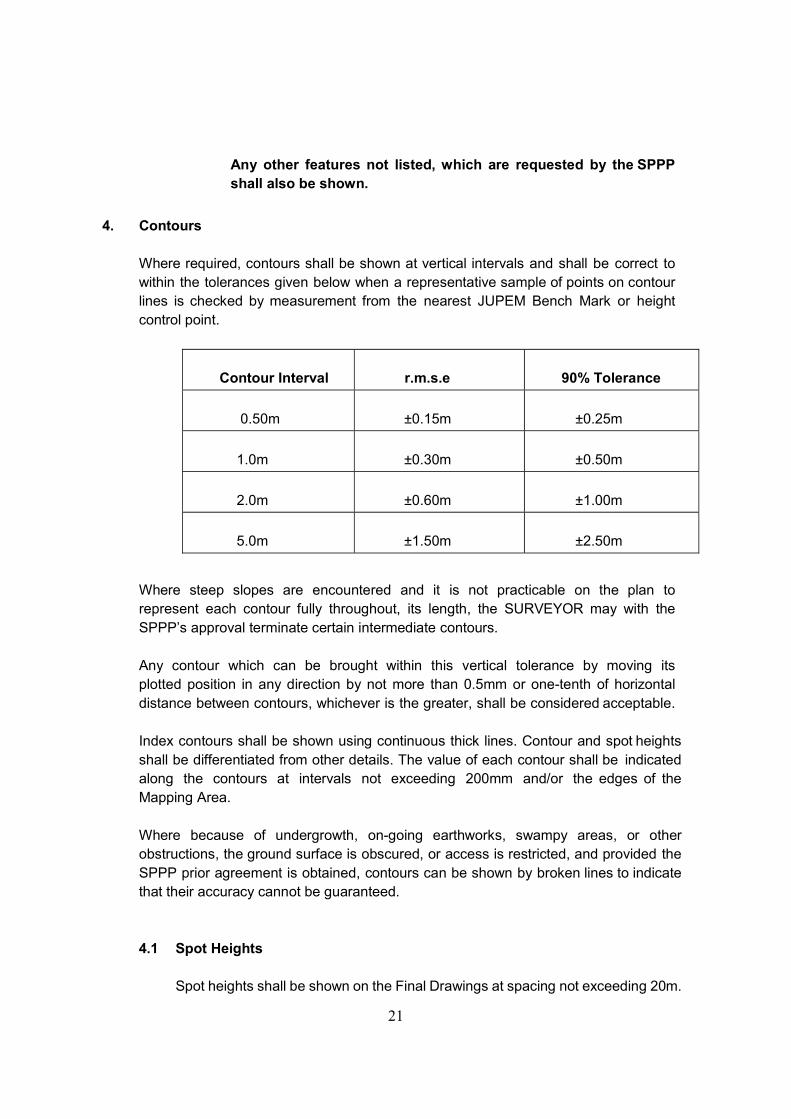
4. Contours
Where required, contours shall be shown at vertical intervals and shall be correct to within the tolerances given below when a representative sample of points on contour lines is checked by measurement from the nearest JUPEM Bench Mark or height control point.
Contour Interval
r.m.s.e
90% Tolerance
0.50m
±0.15m
±0.25m
1.0m
±0.30m
±0.50m
2.0m
±0.60m
±1.00m
5.0m
±1.50m
±2.50m
Where steep slopes are encountered and it is not practicable on the plan to represent each contour fully throughout, its length, the SURVEYOR may with the SPPP’s approval terminate certain intermediate contours. Any contour which can be brought within this vertical tolerance by moving its plotted position in any direction by not more than 0.5mm or one-tenth of horizontal distance between contours, whichever is the greater, shall be considered acceptable. Index contours shall be shown using continuous thick lines. Contour and spot heights shall be differentiated from other details. The value of each contour shall be indicated along the contours at intervals not exceeding 200mm and/or the edges of the Mapping Area. Where because of undergrowth, on-going earthworks, swampy areas, or other obstructions, the ground surface is obscured, or access is restricted, and provided the SPPP prior agreement is obtained, contours can be shown by broken lines to indicate that their accuracy cannot be guaranteed.
4.1 Spot Heights
Spot heights shall be shown on the Final Drawings at spacing not exceeding 20m.

22
at the following locations:-
(a) At salient points such as hilltops, bottoms of depressions and saddles
(b) Along the centre and edges of all roads and public accesses, at
road intersections and significant changes of gradient.
(c) At water level at the time of survey along rivers, streams, major watercourses and ditched
(d) On bed levels of rivers, streams, canals and other watercourses.
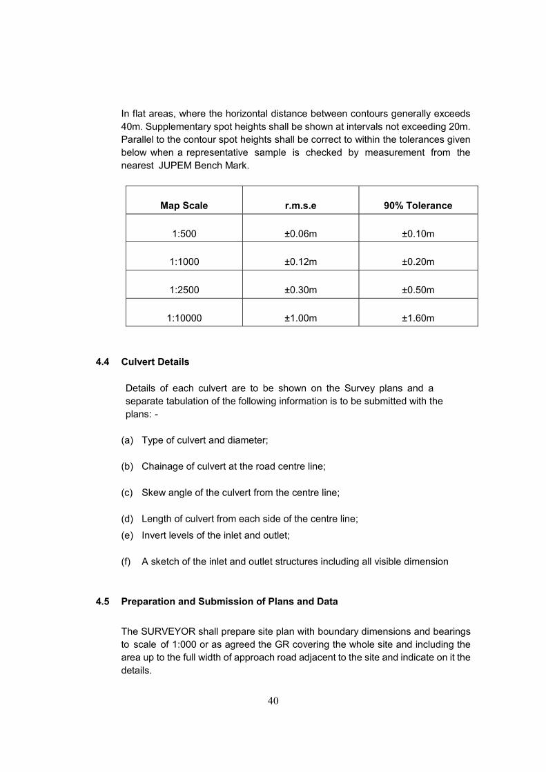
In flat areas, where the horizontal distance between contours generally exceeds 40m. Supplementary spot heights shall be shown at intervals not exceeding 20m. Parallel to the contour Spot heights shall be correct to within the tolerances given below when a representative sample is checked by measurement from the nearest JUPEM Bench Mark.
Map Scale
r.m.s.e
90% Tolerance
1:500
±0.06m
±0.10m
1:1000
±0.12m
±0.20m
1:2500
±0.30m
±0.50m
1:10000
±1.00m
±1.60m
4.2 Bridge Details
Where required the bridge details shall be shown on a separate drawing for each bridge in a form agreed by the SPPP. They shall not be shown on the map. The bridge details shall include:- (a) The coordinates and levels of the four corners of the bridge (points shall
be are on the adjacent road road surface), the two edges of the piers, abutment and wing wall.
23
(b) The coordinates and levels of the bridge deck on the intermediate piers
(if any) of the bridge.
(c) Length, width and type of construction of bridge. (d) The type and location of services adjacent to the bridge. (e) The Co-ordinates and levels of the centre line and the two edges of
the road on the bridge at approximate intervals of 5 metres.
(f) The cross-sectional clearance envelope at the two sides of an overpass bridge (with respect to the road centre line passing underneath) showing all the relevant levels, offsets and skew angle.
4.3 Culvert Details
Details of each culvert are to be shown on the Survey plans and a separate tabulation of the following information is to be submitted with the plans:-
(a) Type of culvert and diameter; (b) Chainage of culvert at the road centre line; (c) Skew angle of the culvert from the centre line; (d) Length of culvert from each side of the centre line; (e) Invert levels of the inlet and outlet; (f) A sketch of the inlet and outlet structures including all visible
dimension to a scale of 1:200.
For major culverts (diameter ≥2.0m) the outlet structures to be properly measured and modelled as 3D strings.
4.4 Preparation and Submission of Plans and Data
The SURVEYOR shall provide the SPPP with two sets of prints together with one set of Master transparency for all drawings prepared. The drawings required are as follows:-

24
4.4.1 Location Plan and Alignment Control Plan
Location plan of the proposed roads to suitable scale such that the area under study can be put into a single standard A1 size sheet. The chainage of the survey alignment shall be indicated for ease of reference to the detail plans. Alignment control plan shall be prepared as described in Arahan Teknik (Jalan) 6/85.
4.4.2 Preliminary Survey Plans and Data
The plans and data shall contain all the essential details so as to enable the SPPP to make decisions in choosing the best alignment of the proposed road.
The details may include the following:-
(a) Contours (b) Grid Lines (c) Structures, buildings or any obstructions (d) River crossings (e) Rock outcrops (f) Swampy areas (g) Existing roads, tracks, railways, etc. (h) Transmission lines
The SURVEYOR shall provide other additional details and data wherever instructed by the SPPP.
4.4.3 Final Survey Plans
The plans shall be shown in a scale 1:1000. These shall show the Alignment, Permanent Ground Markers, Chainage and all other features.

25
4.4.4 Detail Plans for Bridges and Culvert Sites
The sites shall be produced in a scale of 1:500 showing features and levels. Details of any adjacent existing bridges in shall be shown as a separate figure with all the relevant dimension in a suitable scale.
4.4.5 Plans for Junction or Site Details
Whenever shown on the drawings or as instructed by the SPPP, the SURVEYOR shall provide plans that show details of junctions or Site to a Scale of 1:500.
4.4.6 Land Acquisition Plans
The SURVEYOR shall compile and prepare base plans for property, land acquisition and applications purpose from the JUPEM’s cadastral maps and latest revenue sheets from the Land Office and other relevant SPPP agencies to the same scale all in accordance with JKR guidelines as described in Arahan Teknik (Jalan)7/85. The drawings shall show the following:-
(a) Lot boundaries (b) Lot numbers (c) Existing total lot areas computed based on coordinates
(Determination of areas by measurement is not permitted). (d) Land use indicating type of cultivation, etc. (e) Types of buildings indicating permanent or semi-permanent and
usage (f) The existence of burial ground if any Surveyor within the survey
corridor. (g) Other relevant details as instructed by the SPPP
Land lots that are partially within the mapping area shall be presented showing the whole area of that lot. All coordinates shall be computed and all calculations shall be presented as an appendix in a neat and clean form as agreed by the

26
SPPP. Coordinates shall be presented based in the transformation factor.
The drawings of this plan does not include the preparation of the final land acquisition plan nor the computation of the area to be acquired.
4.4.7 Format of Drawings to Be Submitted 4.4.7.1 Format for Presentation
Unless otherwise specified in The Terms of Reference, all formats of drawings submitted including the title block shall conform to JKR Guidelines as contained in Arahan Teknik (Jalan) 6/85 (Guidelines For Presentation of Engineering Drawings). All drawings shall to be A1 size unless otherwise specified. Unless otherwise specified all txt and annotations shall be in English
All legends any symbols used in drawings shall be those currently used by JKR for the standard MOSS drawing output and approval must be obtained for any departure from accepted practice. RSO (Malaya) grid lines shall be show by symmetrical lines at 100mm. intervals for Peninsular Malaysia; while RSO (Borneo) Grid lines shall be shown by symmetrical lines at 100mm. intervals for Sabah, Sarawak and FT of Labuan. For Peninsular Malaysia, State Cassini-Soldner grid lines (if so required by the SPPP) shall be shown at 100mm. Intervals by symmetrical crosses (10mm. North-South and 10mm East-West). Coordinates shall be shown outside the band of detail, or at the sheet edges at 100m interval.
4.4.7.2 Preliminary Copies
Preliminary copies shall be submitted in the form of stable based paper printed by diazo process. Every sheet of the drawings shall be marked as Preliminary copy.
27
4.4.7.3 Final Survey Drawings
All Final Survey Drawings shall bear the name, signature and qualification of the SURVEYOR as well as the name and address of his company. Final Drawings shall consist of two (2) set of paper prints and if necessary further copies until approved. One (1) set of readable/editable softcopy plans on compact disks (CDs) shall also be provided in Autocad format.
4.4.8 Format of Data to be Submitted
4.4.8.1 Filing Conventions
(a) Restrict the filename length to eight (8) character. (b) The filename extension shall be used with prior approval
from the SPPP. (c) Any additional extension shall be s required or requested
by SPPP.
4.4.8.2 Work Directory
Main Directory Pathname for working area shall be provided by the SPPP.
4.4.8.3 Data Media
The SURVEYOR shall submit the survey data in CD-ROM or DVD-ROM in DWG format.
4.5 Date of Submission of Drawings and Data
4.5.1 Survey Drawings and Data for Preliminary Design
Drawings and Data are to be prepared and submitted to the SPPP within 2 weeks after completion of the relevant field works and prior to the preparation of other drawings. Whenever necessary the plans and data may be delivered in stages as instructed by the SPPP.

28
4.5.2 Completed Survey Drawings and Data
All survey drawings and data are to be prepared and submitted to the SPPP within 4 weeks after completion of the relevant field works.
5. Field Books and Finale Survey Report
All field books and computer data must be properly kept and shall record truthfully all the survey work carried out. The SURVEYOR shall do all workings in proper books, adequately in good style and according to best practice. All field books shall be struck off and there be no superimposed writing or erasure. The GR may check the field books now and then to ensure that a high standard of work is maintained. He may request the SURVEYOR to carry out some spot checks if he has reasonable doubt on the accuracy of the survey work. The SURVEYOR shall comply with such requests unless he can prove to the SPPP’s representative’s satisfaction that such checks are unnecessary. The SURVEYOR may propose the use of electronic equipment for the purpose of booking. The type of equipment is subject to the SPPP’s approval. On completion of survey work, all field books and computer data shall be properly labelled and compiled and submitted to JKR and shall remain the property of the SPPP. All field books and survey data, plans and drawings shall be duly certified by the SURVEYOR.

29
SERVICES SPECIFICATIONS FOR TOPOGRAPHICAL SURVEY WORKS
1. Professional Land Surveying Services for Topographical survey works
The services to be rendered by the SURVEYOR in this paragraph include the provision of all expert of all expert technical advice which are normally required for the Works for which the SURVEYOR has been engaged.
a. General
The Services to be provided by the SURVEYOR as listed herein and as detailed in subsequent sections: -
i. Prior discussion with relevant authorities such as JKR, PDRM land
Office and local authorities before the physical commencement of work on site.
ii. Study all relevant information and maps provided and obtain additional data if necessary for the proper execution of the works.
iii. Field survey and picking up of mapping details for subsequent submission of digital data in DWG (Autocad) format.
iv. Establishment of Permanent Ground Markers for survey control such as Survey Markers and Temporary Bench Marks.
v. Compilation, processing and preparation of data in accordance to DWG format (Autocad)
2. Accuracies, Tolerances, Errors And Corrections
Wherever accuracies or tolerances are specified herein, they are defined as Maximum Errors or statistically based root mean square errors (r.m.s.e) as follows: - 2.1 Maximum Errors
Maximum errors are only for fieldwork misclosures and plotting of map grids and control points. All errors exceeding the maximum allowable tolerance including consequential errors shall be corrected by the SURVEYOR at his own expenses.

30
2.2 Method and Location of Corrections The SURVEYOR shall agree with the SPPP the method, location and extent of the work to be corrected.
3. Fieldwork
3.1 Planimetric Control
For Peninsular Malaysia, planimetric control shell be calculated based on the relevant State Cassini-Soldner Geocentric Grid as agreed by the SPPP. For Sabah, Sarawak and the Federal Territory of Labuan, planimetric control shall be calculated based on the relevant Rectified Skew Orthomorphic (Borneo) Grid as agreed by the SPPP Azimuths shall be checked by solar observations at appropriate intervals and the survey traverses shall tied up to any nearby trigonometrical points or standard traverse points or permanent GPS points or Boundary Mark. The maximum closing error of the traverse shall be 1:4000. Survey should be started from the Local Survey Datum. Existing boundary marks within and adjacent to the work site shall be located. Replacement with temporary markers shall be done when the boundary marks are found to be missing.
3.2 Height Datum and Vertical Accuracies
All heights supplied by the SURVEYOR shall be related to the latest published values of JUPEM Bench Marks at the time of survey. JUPEM Bench Marks which exceed these tolerances shall be omitted from the adjustment. The SURVEYOR shall inform the GR and JUPEM whenever the JUPEM Bench Marks are found to be damaged or in error. At least three (3) Temporary Bench Mark (TBMs) shall be established at the work site and indicated the same on plan. The TBM shall be of solid construction shall be of concrete. All Temporary Bench Marks shall be connected by a closed levelling net which shall be tied to a minimum of two JUPEM Bench Marks unless otherwise agreed by the SPPP. All levelling shall be done in sections of approximately 1 km. in length
31
Vertical misclosures within the levelling net and between JUPEM bench marks shall not exceed the lesser of the following: - (a) ± 16mm (b) ± (20 √K) mm where K is the sum of the distances levelled in
kilometres. Levelling shall be carried out with spot height at 10m. interval & contour lines should cover the whole of site and 20 meters beyond the boundaries and any other areas indicated in red in the attached Requisition Plan in Appendix 6.
3.3 Permanent Ground Markers
Permanent Ground Markers shall include the following: -
(a) Survey Markers (SMs)
(b) Temporary Bench Marks (TBMs)
The SURVEYOR shall construct, coordinate and height Permanent Ground Markers to the Satisfaction of the SPPP at the location where points are required to form a reference system for future setting out of the works at the approximate locations indicate on the Drawings, clear of future construction works and as agreed with the SPPP. The types of marker which will be considered acceptable for the appropriate general ground surface conditions. Alternative forms of marker submitted by the SURVEYOR may however be considered. The SPPP will indicate on the Drawings the likely types of the permanent Grounds Marker to be installed within the site. The final locations and types of markers shall be agreed with the SPPP before emplacement. All Permanent Grounds Markers shall be clearly and legibly inscribed to distinguish between SM and TBM. There shall be a joint inspection and handling over of all Permanent Ground Markers to the GR.
32
3.3.1 Survey Marks
Whenever required by the SPPP, the SURVEYOR shall erect permanent Survey Markers at locations indicated in the Drawings or as agreed by the SPPP.
3.3.2 Temporary Bench Marks
The SURVEYOR shall establish Temporary Bench Marks at approximately 1km. intervals and reference it to the JUPEM Datum. Reduced levels of these temporary bench marks shall be clearly and legibly inscribed and referenced for identification for subsequent construction stage. The SURVEYOR shall supply two copies of diagrams of the levelling net indicating the connections between Permanent Ground Markers, Temporary Bench Marks and JUPEM Bench Marks with misclosures to the SPPP on completion of fieldwork and survey adjustment.
3.4 Topographic Detail Survey
All details and up the full width of the approach road fronting the land shall be picked up, inclusive of the following: -
(a) North Point; (b) All boundary marks; (c) Road names, pavement, side tables, road islands, meridian and
intersections; (d) Visible manhole, inspection cover, sump and their invert levels, if
necessary; (e) Water supply pipes and water mains-water pressure; (f) Drain, culvert and invert levels – direction of flow; (g) Electricity and telegraph poles and pylon; (h) Existing temporary and permanent buildings in and around sites; (i) Fencing – types and weight; (j) River, stream, inverts and flood levels;

33
(k) All others visible obstacles for future construction, e.g. flood levels, and
etc; (l) Prominent trees 0.3 metre in circumference and bigger; and (m) Railway track, rock, outcrops and etc.
3.4.1 Survey of Watercourses
(a) Streams and Rivers
The SURVEYOR shall survey all streams, rivers and watercourses crossing or located adjacent to the Work site. These include all watercourses whether there is water or no water flow at the time of surveying.
(b) Urban Drainage
The SURVEYOR shall survey all top and bottom edges and invert levels of urban drains at intervals not exceeding 10m, showing all significant changes of level and direction of flow. The type, width and depth of each section of different drainage system (including sumps) shall be recorded.
(c) Culverts
All the relevant details of the culvert shall be recorded.
(d) Flood Information
The SURVEYOR shall record the maximum flood level at each river crossing. Existing water surface at suitable points shall be taken along the channel.
In areas where tidal effects are significant, the SURVEYOR shall gather all the necessary information as an appendix to the mapping in a form agreed by the SPPP.

34
4. Mapping
(a) Unit of Measurement
Metric units shall be used throughout.
(b) Scale
Mapping on final drawings shall be plotted to a scale of 1:1000
(c) Control and Detail Accuracy
Mapping shall be based on the Planimetric Control. Permanent Ground Markers shall be drawn to an accuracy of ±0.3mm maximum tolerance. Well defined points of details shall be plotted in their true positions at map scale to ±0.3mm root mean square error when coordinated scaled off the map are compared with coordinates determined by measurement on the ground from the nearest Permanent Ground Markers. (90% of a representative sample of well- defined points shall be within ± 0.5mm)
Master transparencies shall be permitted to have an additional tolerance for shrinkage of their stable based material not exceeding ±0.3mm per metre.
4.1 Features To Be Shown:
4.1.1 Building/Structures
(a) The plinth line of all permanent buildings.
(b) Construction type of building, whether Wooden (W), Semi-Conc.(SC), Concrete (C), Double-Storey (D), and etc.
(c) Ruins or partially demolished buildings or foundations – by the wall and masonry visible at the time of the survey.
(d) Names and type of usage of all buildings, schools, and etc. (e) Buildings under construction.

35
4.1.2 Boundary Features
(a) Fences and gates (b) Boundary stones located/used for fieldwork (c) Land parcels and their lot numbers (d) Wall (e) Burial grounds (Indicate whether Muslim, Chinese,
Christian, Hindu, and etc.) (f) Historical sites
4.1.3 Railways
(a) Gauge faces of railway running rails (b) Level crossings (c) Platforms (d) Bridges (over roads, river, etc.) (e) Station Buildings (f) Telegraph poles (indicate the reference numbers)
4.1.4 Roads, Tracks and Footpaths
(a) Kerb line or edge of surfing to carriageways. (b) Tracks (c) Pedestrian bridges and footpaths (d) Traffic islands (similar to kerb line.)
(e) Destination of road from junction level (f) Bridges (over Railway, rivers, etc.)
36
4.1.5 Road Furniture
(a) Kilometer post (value to be noted)
(b) Bus stop facilities
(c) Traffic signal posts and controllers
(d) Guardrails
(e) Road signs
4.1.6 Industrial
(a) Tanks (indicate type of material stored e.g. fuel, gas, water, and etc.)
(b) Sewage disposal works details
(c) Chimneys (substantial)
4.1.7 Slopes and Earthworks
(a) Cutting and Embankments
(b) Terraced slopes
(c) Borrow pits/Quarries (d) Retaining wall Surveyor (e) Rock outcrops (f) Mining tips (g) Indicate date of survey if on-going earthworks are
present and marks the affected area.
4.1.8 Services and Utilities
(a) Transformers (boundary fences only) (b) Electricity Sub-stations and switch boxes (boundary

37
fences only) (c) Pylon lines (indicate levels at lowest point at sag and at
pylon towers) (d) Pylon bases (e) Pylon reference numbers and voltage of transmission (f) Radio, TV station masts or towers (g) Telecom poles (h) Electricity poles (i) Fire hydrants (j) Water mains pipes and Stop valves (Indicate diameter of
pipe) (k) Manholes (circular and square)
4.1.9 Survey Controls
(a) JUPEM’s Trigonometrical Stations (b) Permanent GPS points (c) Permanent Ground Markers (IPs, RMs, TBMs, etc) (d) JUPEM Bench Marks used (Indicate reference number and
height level)
4.1.10 Woods, Trees & Recreation Areas
(a) Playing fields (b) Prominent trees (c) Land-use and vegetation, and etc.
4.1.11 Water, Drainage and Coastal Features
(a) Lakes
38
(b) Ponds or mining pools (c) Reservoirs (d) Rivers (Name to be indicated) (e) Streams (f) Ditches (width and depth to be indicated) (g) Canals (h) Swamps (i) Lined drains (width, depth and type to be indicate) (j) Water towers (k) Culverts (l) Jetties
The top of banks of all water over 1.0-metre-wide shall be detailed and the bottom of banks as indicated by the water level at the time of the survey. The direction of flow of all rivers, streams and watercourses shall be indicated.
Slopes with a height greater than 1.0 metre of too sharp a gradient to be shown by contours, including river and stream banks are to be shown on conventional markings and the top and bottom of slopes are to be shown as dotted lines. Slopes conventions shall be drawn as near as possible to indicate the actual shape of the slope face, i.e. all beams and terraces shall be detailed.
Any other features not listed, which are requested by the SPPP shall also be shown.
4.2 Contours
Where required, contours shall be shown at vertical intervals as described in Sub- paragraph 1.3.7 and shall be correct to within the tolerances given below when

39
a representative sample of points on contour lines is checked by measurement from the nearest JUPEM Bench Mark or height control point.
Contour Interval
r.m.s.e
90% Tolerance
1.0m
±0.30m
±0.50m
2.0m
±0.60m
±1.00m
3.0m
±0.90m
±1.50m
Where steep slopes are encountered and it is not practicable on the plan to represent each contour fully throughout, its length, the SURVEYOR may with the SPPP’s approval terminate certain intermediate contours. Any contour which can be brought within this vertical tolerance by moving its plotted position in any direction by not more than 0.5mm or one-tenth of horizontal distance between contours, whichever is the greater, shall be considered acceptable. Index contours shall be shown using continuous thick lines. Contour and spot heights shall be differentiated from other details. The value of each contour shall be indicated along the contours at intervals not exceeding 200mm and/or the edges of the Mapping Area. Where because of undergrowth, on-going earthworks, swampy areas, or other obstructions, the ground surface is obscured, or access is restricted, and provided the SPPP prior agreement is obtained, contours can be shown by broken lines to indicate that their accuracy cannot be guaranteed.
4.3 Spot Heights
Spot heights shall be shown on the Final Drawings at spacing not exceeding 20m. at the following locations: -
(a) At salient points such as hilltops, bottoms of depressions and saddles (b) Along the centre and edges of all roads and public accesses, at road
intersections and significant changes of gradient.
(c) At water level at the time of survey along rivers, streams, major watercourses and ditched
(d) On bed levels of rivers, streams, canals and other watercourses.
40
In flat areas, where the horizontal distance between contours generally exceeds 40m. Supplementary spot heights shall be shown at intervals not exceeding 20m. Parallel to the contour spot heights shall be correct to within the tolerances given below when a representative sample is checked by measurement from the nearest JUPEM Bench Mark.
Map Scale
r.m.s.e
90% Tolerance
1:500
±0.06m
±0.10m
1:1000
±0.12m
±0.20m
1:2500
±0.30m
±0.50m
1:10000
±1.00m
±1.60m
4.4 Culvert Details
Details of each culvert are to be shown on the Survey plans and a separate tabulation of the following information is to be submitted with the plans: -
(a) Type of culvert and diameter; (b) Chainage of culvert at the road centre line; (c) Skew angle of the culvert from the centre line; (d) Length of culvert from each side of the centre line;
(e) Invert levels of the inlet and outlet; (f) A sketch of the inlet and outlet structures including all visible dimension
4.5 Preparation and Submission of Plans and Data
The SURVEYOR shall prepare site plan with boundary dimensions and bearings to scale of 1:000 or as agreed the GR covering the whole site and including the area up to the full width of approach road adjacent to the site and indicate on it the details.
41
The SURVEYOR shall state whether site is liable to flooding, and if it is, state the highest water levels experienced or likely to experience.
4.5.1 Key Plan and location Plan
Key Plan and location Plan of the proposed site shall be shown to a suitable small scale such that the area under study can be including into a single standard A1 size sheet as part of the Final Survey Plan.
4.5.2 Final Survey Plan
The plan shall consist of site plan, Key Plan and Location Plan.
4.5.3 Detail Plans for Culvert Sites
Detail of any adjacent existing culverts shall be shown as a separate figure with all the relevant dimensions in a suitable scale.
4.5.4 Format of Drawings to Be Submitted
4.5.4.1 Format for Presentation
All drawings shall be to A1 size unless otherwise specified. All legends and symbols used in the drawings shall be those currently used by JKR for the standard MOSS drawings output and approval must be obtained for any departure from accepted practice.
For Peninsular Malaysia, State Cassini- Solder grid lines (if so required by the SPPP) shall be shown at 100mm. Intervals by symmetrical crosses (10mm.North- south and 10mm (East - West). Coordinates shall be shown outside the band of detail, or at the west sheet edges at 100m. Interval.
4.5.4.2 Final Survey Drawings
Approved Final Drawings shall be plotted on suitable paper material. The SURVEYOR shall submit one (1) set of hardcopy plans on tracing paper, two (2) sets of paper prints and (1) set of readable / editable softcopy plans on compact disks (CDs) on in

42
AutoCAD format. All Final Drawings shall bear the same name, signature and qualification of the SURVEYOR as well as the same and address of his company.

43
LAMPIRAN B
KLAUSA PENCEGAHAN RASUAH DALAM DOKUMEN
PEROLEHAN KERAJAAN
“Termination on Corruption, Unlawful or Illegal Activities
(a) Without prejudice to any other rights of the Government, if the
[Company/Firm], its personnel, servants or employees is convicted by a court of
law for corruption or unlawful or illegal activities in relation to this
[Agreement/Contract] or any other agreement that the [Company/Firm] may
have with the Government, the Government shall be entitled to terminate this
[Agreement/Contract] at any time, by giving immediate written notice to that
effect to the [Company/Firm].
(b) Upon such termination, the Government shall be entitled to all losses, costs,
damages and expenses (including any incidental costs and expenses) incurred
by the Government arising from such termination.
(c) For the avoidance of doubt, the Parties hereby agree that the
[Company/Firm] shall not be entitled to any form of losses including loss of profit,
damages, claims or whatsoever upon termination of this [Agreement/Contract].”